
The Railway Footpath- a Very Lengthy Saga
 |
| Train approaching Castle Douglas. My parent's house marked X. Golf course on left, sewage works on right |
I was brought up with the sound of steam trains and railway whistles. My parents’ house is next to what was the 10 mile Castle Douglas to Kirkcudbright railway. The house is beside a cutting just before the railway curved round to join the main (single track, long and straggling) line from Stranraer. The two lines then passed Castle Douglas Signal Box 2 before entering Castle Douglas station together.
The Distant signal was in the cutting and trains from Kirkcudbright would pause and whistle to let the signalman know they were ready to enter the station. Prompted by the whistle, the signalman would raise the signal and the two carriage train would proceed into the station. Sometimes my father would lift me up on the wall so I could wave at the driver and fireman.
 |
| Castle Douglas Signal Box 2. Kirkcudbright branch on right, Stranraer line on left. |
In June 1965 the Kirkcudbright branch and the Dumfries to Stranraer line were closed. Even before it shut, with my school friend Stephen Briggs I had trespassed on the line, bravely walking on the track under the Abercromby Road bridge. The tracks were lifted just over a year later, but before they had been lifted my father took me and my brother Ian for a walk along the line.
We walked out beside the Castle Douglas Golf Course, the sewage works and the ever smouldering and smoking town cowp (Scots for ‘tip’ as in rubbish tip) as far as the Carlingwark Lane canal. We then walked alongside the canal to the Blackpark Marsh pumping station (built 1938) and then back into town via Blackpark farm road and the railway.
 |
| Train approaching Blackpark bridge. Town rubbish dump on right. |
I did not know then that the slow flowing stream we walked beside was a canal. My father called it the Tarry Burn, although properly the Tarry Burn was the stream which flowed from the town gas works and sewage works into the canal. Lane is a local dialect work for a slow flowing stream, originally a Scots Gaelic work ‘leanna’ which means marshy meadow rather than stream.

Even after the railway track and sleepers were lifted, for a few years more the small iron bridge over the Carlingwark Lane survived. With school friends and Ian we would walk out across the bridge towards Barley Hill, or explore the Blackpark Marshes. It was a very quiet place apart from occasional flocks of lapwings rising up from a shallow lagoon in the marshes. The lagoon has strange stumpy ‘fingers’ leading out from it. I have seen illustrations of similar shallow lagoons which were created by wildfowlers. The ‘fingers’ would be netted and wildfowl driven into the nets.
 |
| The marshes between Carlingwak Loch and the river Dee in 1755 |
In the winter of 1974/5 there was a big flood. Part of the earth bank/ bund beside the pumping station got washed away. The railway embankment became a narrow peninsula jutting out into a the swirling waters.
 |
| Letter confirming that Castle Douglas Burgh bought former railway land from British Railways in 1971. If only a footpath had been made back then... |
Part Two - The By-Pass is built and I return to Castle Douglas
Then, in 1987, the whole area was transformed. A by-pass was built to carry the A 75 around Castle Douglas. It was carried on a 30 foot high embankment across the marshes with a bridge over the Carlingwark Lane canal. I was living in London then, but when I moved back to Castle Douglas in 1997 and began re-exploring the surrounding countryside, the by-pass was the biggest change to the landscape.
I was now living just across the road from my parents and found it was possible- with difficulty- to walk from my backdoor down to Blackpark road, cut across what had been the cowp but was now in the process of being converted into an extension of the golf course, along the old railway embankment, cross the canal by using the by-pass bridge, carefully clamber over a barbed wire fence, walk across a field and then pick up the old railway again, now converted into a footpath by the National Trust for Scotland.
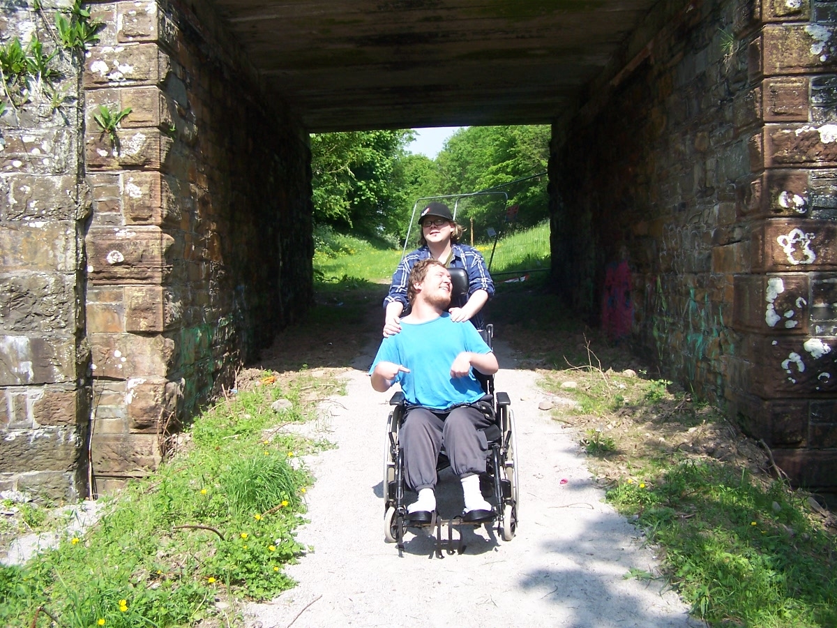
 |
| Beneath Abercomby Road bridge, no access along old railway. |
I could then walk another mile along the railway footpath to an island with a bird hide on the river Dee or walk up to Archibald the Grim’s great castle of Threave on its island in the river. Practically, however, it was easier to walk out of town along the Old Military Road and follow the NTS footpath network from the rear of Threave Gardens or -more often- take a risky short cut along the old A 75 out to Kelton Mains for Threave castle and estate.
 |
| Threave Castle on a wet day. |
The Old Military Road passes Furbar cottage, originally Forbes’ Croft, where the Galloway Levellers had been persuaded not to knock down a recently erected dyke in 1724. A stone in the wall of the dyke here is supposed to commemorate the event, having the date ‘1724’ carved on it. In January 2003 I recorded and interview with Peter Aitchison and Andrew Cassell for their radio series (and book) on the Lowland Clearances there. There is a stone with a date on it, but it is 1757 not 1724.
Part Three- The Railway Path is Proposed
 |
| 2003 poster |
In 2003 I was Secretary to Castle Douglas Food Town and the Food Town were invited to attend meetings of the Castle Douglas Community Initiative. I started going to the meetings and discovered that the Initiative were looking for projects to raise funds for. The Initiative had to do this because Castle Douglas Community Council were not allowed to do this kind of work.
I had a chat with my brothers Ian and Kenneth and we agreed that it was daft that it was easier for people from the town to drive out to Kelton Mains and then walk to Threave Castle and the Nature Reserve rather than being able to walk there. Why not make a path along the old railway so residents and visitors to the town could do what we used to do as kids and walk out to Threave? This would benefit the Food Town by linking it with the countryside where the locally produced food we were promoting came from.
 |
| Map of Proposed Path between Abercromby Road and Barley Hill. Existing paths also shown. |

I put this idea to the Initiative and it was enthusiastically accepted. We then contacted Stephen Wiseman who was the Head Ranger at NTS Threave and Keith Kirk who was the local Dumfries and Galloway Countryside Ranger. Both agreed it was an idea worth pursuing. I think it would have been Keith who put us in touch with Gilbert Clerk who was Dumfries and Galloway’s Access Officer.
 |
| Galloway News 1 May 2003 |
Since my son Callum is a wheelchair user I was keen to make sure that footpath would be wheelchair accessible. I remember walking parts of the route with Gilbert, checking where there were slopes to work out how to make them wheelchair friendly. As Gilbert explained at the time, it would be much more expensive to create a fully accessible footpath. I still have a copy of his estimate for the work. The total was just over £100 000, split over two years. However, by the end of 2004 only £34 860 had been raised.
Unfortunately there was also opposition from two important ‘stakeholders’- Castle Douglas Golf Course and tenant-farmers on NTS Threave Estate.
The first part of the footpath would have been from Abercromby Road to Blackpark Road along the railway embankment beside the Golf Course. From Blackpark Road to the boundary of NTS Threave Estate it would then have run along the edge of the golf course extension. Without permission from the Golf Club, this could not be done.

The next section was to run along the old railway embankment, cross the Carlingwark Lane canal, run under the A 75 by-pass where it crossed the Lane and then alongside an existing fence line across a field to link up with the existing NTS Threave footpath network. The tenant farmers objected to the loss of a strip of the field and were worried that the new path would permit youths to wander out of town vandalising farmed land.

By 2004, the combination of lack of funds and opposition to the footpath seemed to have scuppered the project. In an attempt to keep it going, I included the proposed path in a booklet of walk around Castle Douglas I wrote and published in 2005.
Part Four- The Path Saved by Sewage
I have found some documents from 2004/5 which I will paste into the section.
What saved the footpath turned out to be the sewage works, or more formally Castle Douglas Waste Water Treatment Works. And the Blackpark Marsh Pumping Station. Please bear with me, the next part is complicated…
900 years ago a small stream ran down the western edge of what was to become Castle Douglas. The stream was used to define the boundary between the medieval parish of Crossmichael and the parish of Kelton. Although it has since been culverted and diverted in places, the parish boundary still follows roughly the course of the stream.

When the Victorians built the first sewage works in the town, it was built beside the stream. Treated water from the works flowed into the stream, as did effluent from the town’s gas works and the cowp. Which is why it became called the Tarry Burn. The stream then flowed into the Carlingwark Burn, which was straightened and turned into a canal in 1765. The Kelton/ Crossmichael parish boundary still follows the course of the Carlingwark Burn/ Lane/ canal to the river Dee.
When the Galloway Water Power (hydro-electric) Scheme was built in the 1930s, the average level of water in the river Dee became slightly higher. This affected the flow of water along the Carlingwark Lane so that Blackpark and Carlingwark Marsh were becoming waterlogged, affecting adjacent fields.
The solution found in 1938 was to build a pumping station on the Carlingwark Lane which would act as a barrier to water flowing up from the Dee and keep the water level in the Lane low enough to keep the marshes and farmland reasonably dry.

As Castle Douglas grew through the later twentieth century, the amount of nutrient rich treated waste water from the sewage works increased. This encouraged the growth of weeds and vegetation along the Carlingwark Lane. By 2002 Scottish Power (successor to the Galloway Water Power Company) were complaining that it was costing them a fortune to clear weeds from the pumps of the pumping station and threatened to remove the pumps to save money.
 |
| Pre-2006 outflow from sewage works. Carlingwark Lane choked with weeds. Pumping station near large tree in distance. |
 |
| Threave path and the pumping station 18 May 2004 |
This caused concern- if the pumps were removed, would this lead to an increased risk of flooding in Castle Douglas? Questions were asked - perhaps the landowner of the marshes had a duty to control vegetation in the Lane? The landowner being the National Trust for Scotland, in 2004 I was asked to do some research for the NTS to see if there was a historic responsibility for the landowner to keep the Lane clear of weeds. After a few hours reading through the 1930s/40s records of Castle Douglas Burgh Council in the Stewartry Museum I found that the Ministry of Agriculture had been responsible for keeping the Lane clear of weeds not Threave Estate.
 |
| NTS letter about my research and pipeline proposal |
 |
| Article from DG Nat Hist and Antiquarian Soc Transactions about pumping station, marshes and sewage. |
The implication (backed up by later research) was that the pumping station was not built to control floods but to keep surrounding farmland dry in order to maximise agricultural output- very important in the 1940s.
In meantime, an alternative solution had been proposed. If Scottish Water built a pipeline from their Waste Water Treatment Works to the river Dee, the nutrient rich outflow from the Works could be diverted from the Carlingwark Lane, thus reducing the weed growth problem and so solving Scottish Power’s problem.
This would also solve a critical problem for Dumfries and Galloway Council/ NHS Dumfries and Galloway. In 2005 a new health centre for the town was planned / under construction alongside a new housing development. But this development would increase treated water flow through the sewage works adding to the Carlingwark Lane vegetation problem.
I had a personal interest in this complex situation. Loreburn Housing Association were building a small development in the town, including a specially designed disabled flat for my son’s long term needs. I was therefore also pestering Scottish Water to sort out the problem.
Unfortunately Scottish Water’s original proposal was to run the waste water pipeline directly out to the river Dee along the Carlingwark Lane- straight through the Carlingwark/Threave SSSI marshlands. Scottish Natural Heritage refused to allow this so an alternative route which would run from the Carlingwark Lane along the A 75 to just past Threave Bridge on the A 75 was proposed.
 |
| SNH letter regarding pipeline May 2005 |
Thanks to my pestering of Scottish Water I was sent a copy of the new plans and I remember meeting an SNH person on the by-pass bridge over the Carlingwark Lane to discuss them and the footpath project. Amusingly I got my copy before Dumfries and Galloway Planning Department so was able to make a copy for them as well…
 |
| Scottish Water letter about pipeline |
 |
| Scottish Water pipeline map |
 |
| Spring 2006 - new gate on Blackpark Road. Pipeline work in field. Path now runs along here. |
 |
| A 75 Carlingwark Lane bridge, pipelaying and path making. Close up of pipe and new path heading towards Barley Hill on left. |
 |
| New path looking back to by-pass. Old photo -footpath now follows fence line up to Barley Hill. |
The upshot of this lengthy diversion is that in 2005/6 the pipeline was constructed along most of the route of the 2003 footpath proposal. As the photographs below show, the end result was that a basic footpath was constructed alongside the pipeline from Blackpark Road to Barley Hill and opened by Sir Malcolm Ross, Lord-Lieutenant of the Stewartry of Kirkcudbright in August 2006.
 |
| My article in Galloway News 24 August 2006 |
Part Five- The Core Path Network and the Missing Link
Going back to 2003, the Land Reform (Scotland) Act was passed in that year. This Act included a requirement for local authorities to establish a network of ‘core paths’. It took some time -seven years of consultation between 2006 and 2013- but Dumfries and Galloway’s Core Path Plan was activated in January 2013.
The path from Castle Douglas to Threave Estate was included as Core Path 155. During the consultation phase I and many others had identified the Abercromby Road to Blackpark Road section of the 2003 footpath plan as a ‘missing link’ in the local footpath network. The missing link was included as part of Core Path 155.
 |
| Path under construction in cutting below my parents house, early 2013. |
 |
| Abercromby Road bridge open to traffic again. |
 |
| Callum and sister Beth on newly opened path. Abercromby Road bridge. |
The new section of path was high quality and as soon as it was opened (without any ceremony this time) I took great delight in pushing Callum in his wheelchair along it. Unfortunately we still could not get very far along the 2006 section. Then came The Flood.
Part Six- The Great New Year’s Eve Flood
My son attends Castle Douglas Activity and Resource Centre, a facility for people with physical and learning disabilities. Luckily my son was at home that day, but on 31 December 2105 we had a phone call from the ARC saying they had been flooded and would be closed until further notice. The ARC is on the edge of the Carlingwark Marsh. Local team Threave Rovers’ football pitch is on the other side of the marsh. It was also flooded that day.
 |
| Michael Lowden's photo of flood. X is location of ARC |
After New Year and when the waters had receded, Keith Kirk posed a photo on Facebook. The wooden footbridge over the Carlingwark Lane constructed in 2006 had been washed away and was now lying in a field several hundred yards away.
A few days later I went out to inspect the damage. The bridge really had gone and parts of the footpath had also been washed away. Fortunately, the Scottish Government responded by offering Dumfries and Galloway Council funding to repair flood damage.
In May a notice went up saying ‘Footpath Closed for Restoration Work’. Altogether £60 000 was spent to replace the old bridge with a new, stronger one at a higher level than the old one and to restore and effectively improve the footpath from the Carlingwark Lane to Barley Hill.
By the end of June the path was ready to be reopened. In early July the Galloway News ran a feature on the re-opening and asked myself, Michelle Robertson of Castle Douglas Development Forum and Bryan Scott, Dumfries and Galloway Countryside Development Officer to pose for a photograph on the impressive new bridge.

I took the opportunity to discuss the possibility of upgrading the Blackpark Road to Carlingwark Lane section of the path to the same standard as the newly restored section with Michelle and Bryan. Both agreed it was a do-able project.
Part Seven- Galloway Glens Landscape Partnership
On 1 July the Galloway Glens Heritage Landscape Partnership’s website went live. The Galloway Glens is a major- £2.5 million- Heritage Lottery funded project. Castle Douglas is within the project area. On the website there was a notice that the partnership were looking for project ideas and an ‘Expression of Interest’ form with a 2 September deadline.
I suggested that the Castle Douglas Development Forum might be able to get part funding (40%) from Galloway Glens. Bryan Scott provided a cost of £18 000 to upgrade the Blackpark Road to Carlingwark Lane section It would cost another £3600 to make a ramp from railway level up to the Kelton Mains farm road- this would give access to the path down to Threave Castle and the river Dee. This has been part of the original 2003 footpath plan.
 |
| Original path No. 1 plus three new paths. Glens proposals. |
CDDF put in an Expression of Interest for the path upgrade plus three new footpaths. The proposals were accepted and taken forward to the second stage. This required more details- a 9 page form- with deadline of 2 December.
If successful again, we will find out in January with another deadline of May 2017 to submit fully worked out plans. Which will be a lot to do. For example one of the questions asked in the 2 December form is ‘Does the proposal require planning permission?’
I have checked with Dumfries and Galloway Planning Department and got an answer today. Upgrading Core Path 155 will not require planning permission since it is an existing path, but the three new paths will. I have no idea how difficult it will be do take three paths through the planning process, but it is going to add an extra level of complication to the process.
Part Eight- The Great Expedition
On the other hand, for the first time today myself and Sandy, Callum’s main care worker, managed to get Callum in his wheel chair all the way from home out to the Kelton Mains bridge along Core Path 155.
We sailed along the 2013 Abercromby Road to Blackpark Road section, got up and over the filled in railway bridge on Blackpark Road but then had a struggle to get through the metal swing gate at the start of the 2006 section of path.

The next part was not too difficult since all the grass and nettles which had grown up in the summer while the path was closed had died back. The next part of the path is not surfaced, it is on the grassed over trackbed of the old railway on the embankment that leads towards the Carlingwark Lane canal.

At the canal, the replacement bridge is higher than the old bridge so there is only a short slope down to bridge level. From the bridge, under the A 75 and all the way to the edge of Barley Hill we were on the 2016 upgraded section. The surface is slightly rougher than the 2013 section surface, but was still an easy push.
The last part of the Great Expedition was along the NTS section of railway path. Apart from a couple of soft places it was quite ‘pushable’. At the Kelton Mains bridge over the old railway we stopped, 1 and half miles from home. It had taken us an hour to get there.

The NTS railway path carries on for another mile or so to Lamb Island on the Dee where there is a bird hide. However this section has not been surfaced so is a grass path which is also muddy in places. We could not get up to the Kelton Mains road because of steps. We took some photographs and headed back into town, which took another hour.
It was a great Great Expedition, but also deeply frustrating. 13 years on from having the idea of a path, I was able to get Callum nearly all the way to Threave Castle- or at least the edge of the river Dee.
But it was very awkward to get Callum through the metal swing gate and he did not enjoy the heaving and pushing and bumping. All the other gates on the path are wooden, pull-handle dual-directional and so are no problem. On the 2013 section there are no gates at all, but it has not become a mecca for motorcyclists.
In the late summer we tried to get along the next section, but the grass and nettles had grown up making it impossible. Re-surfacing would be helpful. The long grass and nettles do get strimmed at least couple of times in the summer- I have seen the ‘Community Payback’ team doing this in past years.
 |
| This section has been improved, but may get overgrown again in the summer. |
The unsurfaced section is a problem. It is very bumpy which shoogles Callum and there are soft sections which if it had been wetter would have bogged us down.
And it is frustrating to be able to get along the 2016 improved section, the NTS section and then have to stop under a bridge and go back again. It would also have been much more difficult without Sandy to help in the awkward places.
Part Nine - Is the end of the Railway Footpath Saga in sight?
Perhaps. Unfortunately, by bundling the upgrade with three new paths, it is going to be more difficult, costly and complicated (eg planning permissions) to get the upgrade done as part of the Galloway Glens project. But if it can done, work could start in 2018. The 2013 section only took a couple of months to construct. The 2016 upgrade and new bridge took about two months as well.
 |
| Freight train between Lodge of Kelton and Kelton Mains. |
However, actual construction work is the least complicated part of the process. It took three years from 2003 to 2006 to get the main section of basic path open, 13 years to get half of it to wheelchair pushable standard. It took ten years from 2003 to 2013 to get the Abercromby Road to Blackpark Road section open.
So I will pencil in 2020 as an optimistic date when I will be able to conclude this Railway Footpath Saga and write ‘The End’ …
Below- Stewartry Area Committee Report on Path from December 2005.
But no mention of the pipeline...


posted by Unknown | 1:24 am
|
0 comments
![]()
![]()